Map of Melbourne Suburban Lines 1930s, showing the Inner Circle and the Northcote Loop
Map of Melbourne Suburban Lines 1930s, showing the Inner Circle and the Northcote Loop - PROV, VPRS 12903/P1 Box 527-13; https://prov.vic.gov.au/explore-collection/provenance-journal/provenance-2007/stroll-along-merri

Inner Circle Railway Line

The Inner circle Railway Line was constructed from 1884, after the Victorian Government passed the Railway Construction Act which authorised the vast expansion of the rail network through construction by private companies. In 1884, there was no direct service between Princes Bridge (now Flinders Street) and the Collingwood area, and connecting these inner northern suburbs via rail to the CBD was difficult to route around existing development. The Inner Circle Line worked around existing development by connecting to Royal Park, adding stations at North Carlton (originally Lang St Station) and North Fitzroy (originally Nicholson St Station) and terminating at Rushall, with a branch line running through Edinburgh Gardens. By 1901, however, a more direct route to Collingwood opened on the current route, and in 1948 passenger services were closed on the more indirect Inner Circle line. The Fitzroy History Society put together a walking tour of the Inner Circle line in 2017, which traces the former route and highlights remnants of its infrastructure. https://fitzroyhistorysociety.org.au/wp-content/uploads/2017/11/FitzroyRailwayWalk.pdf

by laurenpiko on March 2, 2019


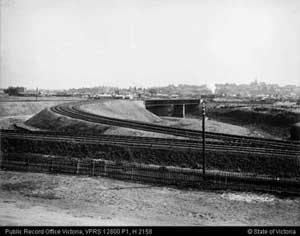
Foreground shows part of the Inner Circle line along what is now Park Street, North Fitzroy.

PROV, VPRS 12800/P1, H2158 https://prov.vic.gov.au/explore-collection/provenance-journal/provenance-2007/stroll-along-merri

Please login to comment on this item